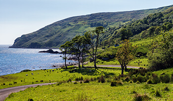
The Inishowen 100 is one of the best scenic drives in Ireland and gets its name from the approximate distance in miles of the signposted drive, which officially starts in Bridgend on the Inishowen Peninsula.
Inishowen is a peninsula of 884.33 square kilometres (218,523 acres), situated in the northernmost part of Ireland. It is bordered to the north by the Atlantic Ocean, to the east by Lough Foyle, and to the west by Lough Swilly. It is joined at the south to the rest of County Donegal, the part known as Tír Conaill, and by County Londonderry. This part of Ireland has the most splendid coastal scenery with Inishowen being one of the highlights. Historically, the area of Derry west of the River Foyle also forms part of Inishowen, the Foyle forming a natural border. Most of Inishowen's population inhabit the peripheral coastal areas, while the interior consists of low mountains, mostly covered in bogland, the highest of which is "Sliabh Sneacht" (from the Irish, meaning Snow Mountain) which is 619 metres (2,030 feet) above sea level. Other major hills are located in the Malin Head peninsula, the most northerly point of Ireland as well as the Urris Hills in west Inishowen. Due to its geography, Inishowen usually has soft weather conditions, with temperatures slightly lower than other parts of Ireland in summer, and slightly warmer in winter, especially during cold spells.
Looking across the mouth of Lough Foyle to Dunagree Point and Inishowen Head. Inishowen has several harbours, some of which are used for commercial fishing purposes, including Greencastle, Bunagee and Leenan. A seasonal ferry service crosses the Foyle, connecting Greencastle with Magilligan in Derry, while another crosses the Swilly, connecting Buncrana with Rathmullan. The village of Fahan has a privately built Marina.
While touring Ireland, there are several small outlying islands to view off the Inishowen coast, most notably Inishtrahull and Glashedy islands, both uninhabited, although the former was inhabited until the early twentieth century. Inch, located in Lough Swilly is technically no longer an island, as it has a causeway connecting it to the mainland at Tooban, south of Fahan.
Lough Swilly is a fjord-like lough, and was of strategic importance for many years to the British Empire as a deep-water harbour. It is also famous as the departure point of the Flight of the Earls. Lough Foyle is important as the entrance to the river Foyle, and the city of Derry, but is much more shallow than Lough Swilly, and requires the use of a guide boat to guide ships to and from the port of Derry.
A large area of land, most of which now forms part of Grianán Farm, one of the largest farms in Ireland, was reclaimed from a shallow area of Lough Swilly, stretching from the village of Burnfoot to Bridgend and Burt. The outline of this land is plainly visible due to its flatness proving a marked contrast to the more mountainous area surrounding it.
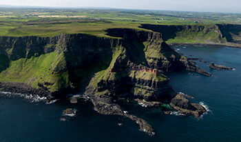
While on your Northern Ireland tour, drive along this northern rugged coastline taking in some of the most stunning scenery Ireland has to offer.
Tours featuring this attraction
Northern Territories 10 Nights
(10 Nights)
Northern Territories Tour (7 Night)
(7 Nights)
Northern Territories Tour (8 Night)
(8 Nights)
All Ireland Tour (12 Night)
(12 Nights)
All Ireland Tour (12 Night)
(12 Nights)
All Ireland Tour (12 Night)
(12 Nights)
All Ireland Tour (12 Night)
(12 Nights)
All Ireland Tour (14 Night)
(14 Nights)
5 Centre Tour of Ireland 14 Nights
(14 Nights)
Peace of Mind Guarantee
Your trip, worry free!Our Ireland based team is on call throughout your vacation!
